Geography
Location: 18 15 S, 35
00 E -- Southern Africa ,
bordering the
Mozambique Channel , between South
Africa and
Tanzania .
Map references: Africa
.
Area: Southern .
total area: 801,590
sq. km
land area: 784,090 sq.
km
comparative area: slightly
less than twice the size of
California
Land boundaries:
total: 4,571 km
border countries: Malawi
1,569 km,South Africa 491 km
Swaziland 105 km, Tanzania
756 km, Zambia 419 km,
Zimbabwe 1,231 km
Coastline: 2,470 km
Maritime claims:
exclusive economic zone:
200 nm
territorial sea: 12
nm
International disputes:
none
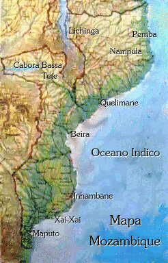
CLICK ON THIS MAP
TO SEE A BIGGER
ONE WITH MORE DETAIL:
Climate: tropical to
subtropical
Terrain: mostly coastal
lowlands, uplands in center,
high plateaus in northwest,
mountains in west
lowest point: Indian
Ocean 0 m
highest point: Mount
Binga 2,436 m
Natural resources: coal,
titanium, natural gas .
Name of country:
conventional long form:
Republic of Mozambique
conventional short form:
Mozambique
local long form: Republic
Popular de Moçambique
local short form: Moçambique
Data code: MZ
Type of government:
republic
Capital: Maputo
Administrative divisions:
10 provinces (provincias,
singular - provincia);
Cabo Delgado, Gaza, Inhambane,
Manica, Maputo, Nampula,
Niassa, Sofala, Tete,
Zambezia .
Independence: 25 June
1975 (from Portugal)
National holiday: Independence
Day, 25 June (1975)
Constitution: 30 November
1990
Legal system: based
on Portuguese civil law system
and customary law
Suffrage: 18 years of
age; universal .